Due to the incoming storm and current weather forecast, we are going to officially cancel tomorrow's hike up Mt. Woodson. We made this decision based on the projected rain schedule for tomorrow. This hike goes up a pretty steep dirt trail, if wet could result in injuring one of our hikers. This is also a hike that you would want to do in more favorable weather to take in the beautiful views.
We're hoping that you'll join us for one of our other upcoming events.
Woodson Mountain: West Approach
Distance 6.6 miles (out-and-back)
Hiking time 4.5 hours
Elevation gain/loss 2,000'
Difficulty Moderately strenuous
Trail use Dog allowed
Best times November - May
Parking fee $10/car
Directions
Exit I-15 at Rancho Bernardo Road and go east. Rancho Bernardo Road becomes Espola Road as you enter the Poway city limits. Espola starts to curve south after about 3 miles. Drive a total of 4 miles from I-15 to reach leake Poway Road. Turn left (east) there, and drive 0.5 miles into the Lake Poway Recreation Area. (If you are arriving from the south via Espola Road, Lake Poway Road is 2.7 miles north of Poway Road.)
Description
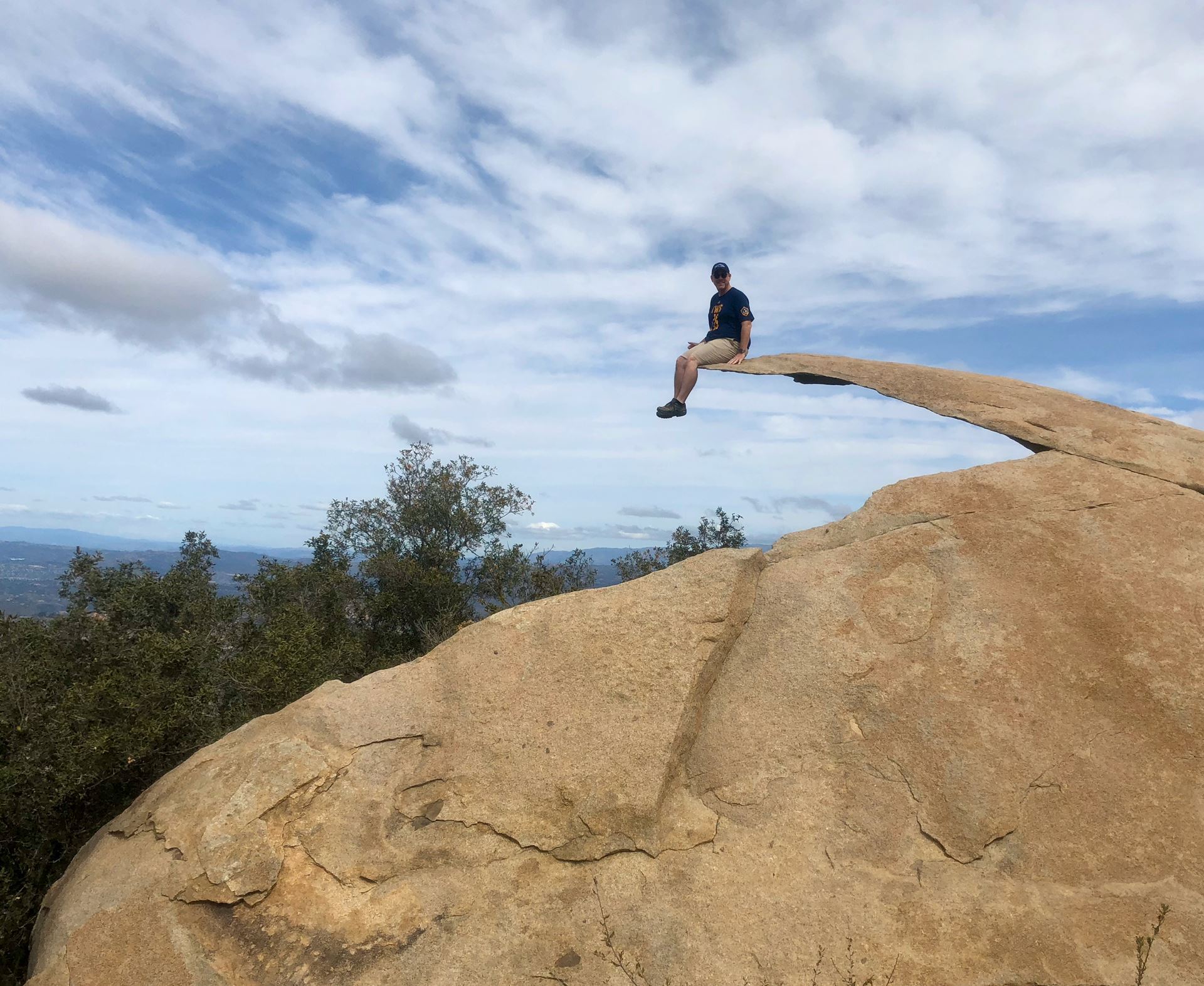
The more challenging and immensely popular hike to Woodson Mountain's summit, commonly referred to as the Potato Chip Rock hike, takes you through a veritable obstacle course of gigantic boulders. The variety of shapes is amazing, from smooth and rounded, angular or shattered, to, of course, the form of a potato chip.
Begin at the grassy picnic area on the southeast shore of Lake Poway, and follow either of two wide trails southeast (they down join together). After skirting the south shore and dipping to cross Warren Canyon, you come to a trail junction at 0.8 mile. Turn right on the signed Mount Woodson Trail and commence a rigorous climb east on a steep grade through sage scrub and chaparral. The white-flowering ceanothus, occurring in dense patches, comes into full bloom hereabouts around March.
From the next signed junction at 1.8 miles, turn left, upslope, on the Mount Woodson Trail. East of here, the poorly maintained Warren Canyon Trail follows a severely undulating course east, toward CA 67 and a proposed bridge that will eventually span the highway and connect with the Iron Mountain Trail Network.
Using the Mount Woodson Trail, you ascend on sunbathed, south-facing slopes, curving around boulders and twisting amid the low-growing chaparral. The ever-widening view across the lowlands to the south and west duly compensates for the sweaty effort.
At 2.4 miles, the tail reaches Woodsons sharply defined summit ridge. To the left you can scramble up some granite slabs to enjoy a great vista to the west. Ahead is the ascending Fry-Koegel Trail. You swing to the right (east), through, and follow the continuation of the Mount Woodson Trail along the summit ridge, heading toward the antenna towers on Woodson Mountain's summit a little over 1 mile away. A final 0.3 mile stretch of trail climbs tot he west end of the service road atop Woodson's bouldery summit. Most hikers elect to stop at the razor-sharp boulder flake popularly dubbed Potato Chip Rock on the left, just as you reach the service road. This geologic feature attracts hikers by the hundreds on weekends, many of whom stand in a long line for the opportunity to have their picture taken atop the flake. Continue another 0.2 mile to each Woodson's highest point.
Don't forget to your 10 essentials, and bring along a lunch to enjoy on the mountain top!